Landsat field delineation — site reviewiSites were not
hand-picked: select_sites.py queries the Trazo4 2024 master
parquet for Mato Grosso, Rondonia and Para, groups fields by MapBiomas
class and by the WRS-2 footprint that images them, then takes the smallest-
and largest-median tile per class and re-centres a 30 km AOI on the
densest window inside it. The same AOIs were then run on
1986, 2005 and 2024 with one checkpoint and one polygon
floor.
Model Trazo4SAlandsatstretch, 256 px chips on the 10 m grid, 8-band two-window Landsat input (harvest first), over 6 AOIs of 30 km in 1986, 2005 and 2024. Open the zoomable polygon map →
All sites
| site | class | regime | WRS-2 | 1986 objects | 2005 objects | 2024 objects | 1986→2024 | 1986 median ha | 2005 median ha | 2024 median ha |
|---|---|---|---|---|---|---|---|---|---|---|
| Query-selected sites, 1986, 2005, 2024 — Chosen by select_sites.py from field size and MapBiomas class, then run unchanged on every year. Polygon floor 0.27 ha. | ||||||||||
| para pasture small | pasture | small | 223/061 | 2,710 | 2,899 | 4,926 | +82% | 1.07 | 1.43 | 1.30 |
| rondonia pasture fishbone | pasture | small | 231/068 | 534 | 3,084 | 6,364 | +1,092% | 6.39 | 3.12 | 2.15 |
| mato grosso pasture large | pasture | large | 228/069 | 165 | 743 | 1,226 | +643% | 1.17 | 29.18 | 25.47 |
| para soy small | soy | small | 227/062 | 440 | 2,150 | 1,811 | +312% | 2.18 | 2.36 | 2.31 |
| mato grosso soy large | soy | large | 225/068 | 86 | 166 | 208 | +142% | 14.29 | 87.79 | 148.09 |
| para palm | palm | uniform | 223/062 | 469 | 963 | 1,560 | +233% | 1.38 | 11.34 | 9.33 |
| Earlier hand-chosen sites — Polygon floor 1.0 ha, the production filter. 2024 only. | ||||||||||
| pucallpa palm | palm | hand-chosen | — | — | — | 932 | — | — | — | 5.31 |
| matogrosso soy | soy | hand-chosen | — | — | — | 1,017 | — | — | — | 9.77 |
| acre pasture | pasture | hand-chosen | — | — | — | 1,299 | — | — | — | 9.55 |
| rondonia pasture | pasture | hand-chosen | — | — | — | 2,591 | — | — | — | 8.42 |
| altoparana hills | mosaic_of_uses | hand-chosen | — | — | — | 3,471 | — | — | — | 1.86 |
| paraguay colonias | soy | hand-chosen | — | — | — | 4,327 | — | — | — | 4.19 |
| irece bahia | other_temporary | hand-chosen | — | — | — | 3,878 | — | — | — | 3.98 |
Polygon floor 0.27 ha (3 Landsat pixels at 30 m). Click any figure to enlarge.
Query-selected sites, 1986, 2005, 2024
Chosen by select_sites.py from field size and MapBiomas class, then run unchanged on every year. Polygon floor 0.27 ha.
para pasture small
Zoom this site →pasture, Para (small fields, tile median 0.7 ha, WRS-2 223/061)
| 1986 | 2005 | 2024 | 1986→2024 | |
|---|---|---|---|---|
| objects found | 2,710 | 2,899 | 4,926 | +82% |
| median ha | 1.07 | 1.43 | 1.30 | — |
| p10 ha | 0.35 | 0.38 | 0.37 | — |
| p90 ha | 7.98 | 20.55 | 14.09 | — |
| total ha | 14,848.60 | 35,204.20 | 37,799.90 | +155% |
1986 · Landsat 5 TM planting 1985-10-01/1986-01-31 · harvest 1986-02-01/1986-05-31
LT05_L2SP_223061_19851002, LT05_L2SP_223061_19851018, LT05_L2SP_223061_19851103, LT05_L2SP_223061_19851205, LT05_L2SP_223061_19860327
2005 · Landsat 5 TM planting 2004-10-01/2005-01-31 · harvest 2005-02-01/2005-05-31
LT05_L2SP_223061_20041123, LT05_L2SP_223061_20050211, LT05_L2SP_223061_20050227, LT05_L2SP_223061_20050315, LT05_L2SP_223061_20050331, LT05_L2SP_223061_20050416, LT05_L2SP_223061_20050518
2024 planting 2023-10-01/2024-01-31 · harvest 2024-02-01/2024-05-31
LC08_L2SP_223061_20231128_, LC08_L2SP_223061_20231214, LC08_L2SP_223061_20231230, LC08_L2SP_223061_20240115, LC08_L2SP_223061_20240131, LC08_L2SP_223061_20240319_, LC08_L2SP_223061_20240404, LC08_L2SP_223061_20240506, LC08_L2SP_223061_20240522, LC09_L2SP_223061_20231206, LC09_L2SP_223061_20231222, LC09_L2SP_223061_20240123, LC09_L2SP_223061_20240327, LC09_L2SP_223061_20240412, LC09_L2SP_223061_20240514, LC09_L2SP_223061_20240530
object count by size 198620052024
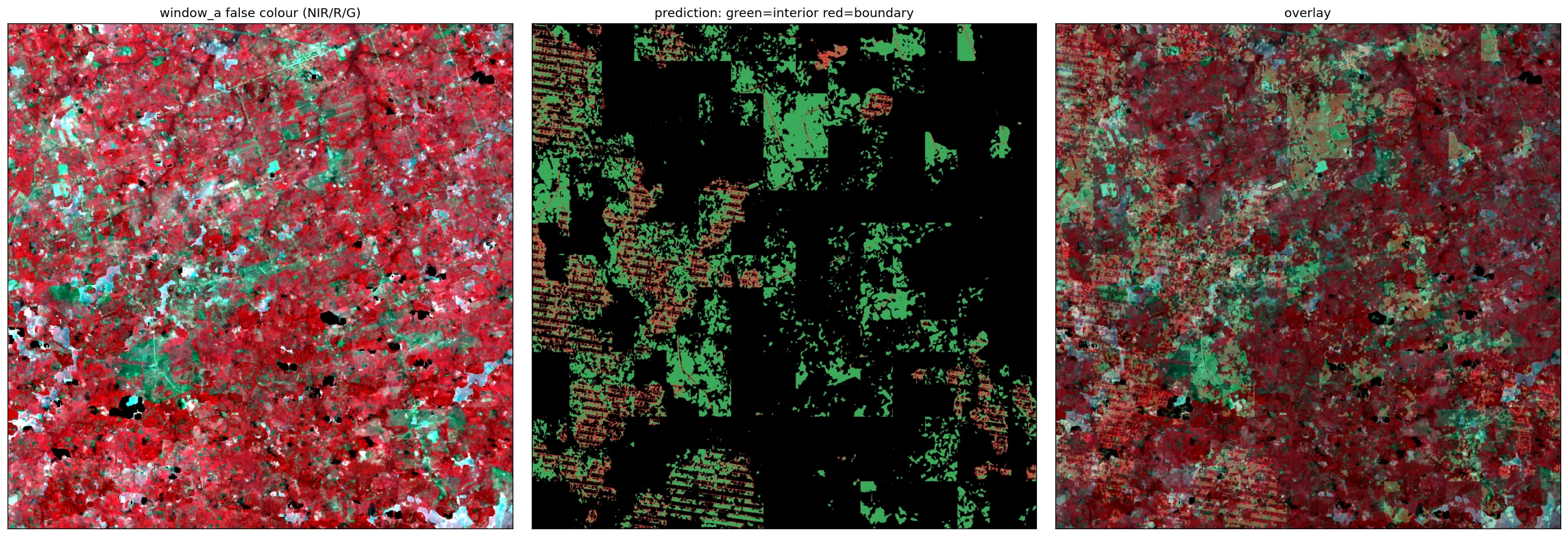


rondonia pasture fishbone
Zoom this site →pasture, Rondonia (fishbone smallholder settlement, tile median 2.1 ha, WRS-2 231/068)
| 1986 | 2005 | 2024 | 1986→2024 | |
|---|---|---|---|---|
| objects found | 534 | 3,084 | 6,364 | +1,092% |
| median ha | 6.39 | 3.12 | 2.15 | — |
| p10 ha | 0.95 | 0.50 | 0.44 | — |
| p90 ha | 64.38 | 28.97 | 15.48 | — |
| total ha | 16,332.10 | 47,729.70 | 44,375.30 | +172% |
1986 · Landsat 5 TM planting 1985-07-01/1985-11-30 · harvest 1986-01-01/1986-05-31
LT05_L2SP_231068_19850908, LT05_L2SP_231068_19860522
2005 · Landsat 5 TM planting 2004-07-01/2004-11-30 · harvest 2005-01-01/2005-05-31
LT05_L2SP_231068_20040928, LT05_L2SP_231068_20050307, LT05_L2SP_231068_20050323, LT05_L2SP_231068_20050408, LT05_L2SP_231068_20050424, LT05_L2SP_231068_20050510, LT05_L2SP_231068_20050526
2024 planting 2023-07-01/2023-11-30 · harvest 2024-01-01/2024-05-31
LC08_L2SP_231068_20231019, LC08_L2SP_231068_20240530
object count by size 198620052024
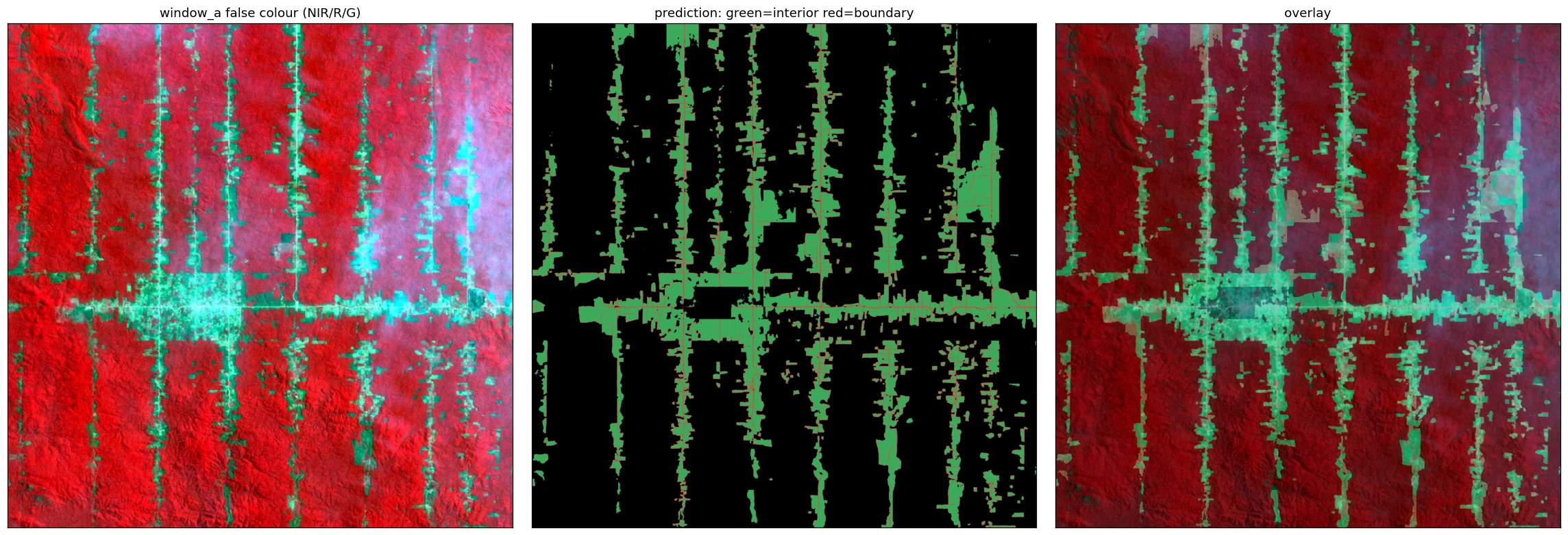


mato grosso pasture large
Zoom this site →pasture, Mato Grosso (large fields, tile median 16.1 ha, WRS-2 228/069)
| 1986 | 2005 | 2024 | 1986→2024 | |
|---|---|---|---|---|
| objects found | 165 | 743 | 1,226 | +643% |
| median ha | 1.17 | 29.18 | 25.47 | — |
| p10 ha | 0.34 | 1.75 | 2.11 | — |
| p90 ha | 34.01 | 106.18 | 89.70 | — |
| total ha | 7,219.30 | 34,334.40 | 48,154.80 | +567% |
1986 · Landsat 5 TM planting 1985-07-01/1985-11-30 · harvest 1986-01-01/1986-05-30
LT05_L2SP_228068_19850701, LT05_L2SP_228068_19860226, LT05_L2SP_228068_19860314, LT05_L2SP_228068_19860415, LT05_L2SP_228068_19860501, LT05_L2SP_228068_19860517, LT05_L2SP_228069_19860314
2005 · Landsat 5 TM planting 2004-07-01/2004-11-30 · harvest 2005-01-01/2005-05-30
LT05_L2SP_228068_20040705, LT05_L2SP_228068_20040806, LT05_L2SP_228068_20040822, LT05_L2SP_228068_20040907_, LT05_L2SP_228068_20040923, LT05_L2SP_228068_20041009, LT05_L2SP_228068_20041110, LT05_L2SP_228068_20041126, LT05_L2SP_228068_20050521
2024 planting 2023-07-01/2023-11-30 · harvest 2024-01-01/2024-05-30
LC08_L2SP_228068_20240509, LC09_L2SP_228068_20230920
object count by size 198620052024
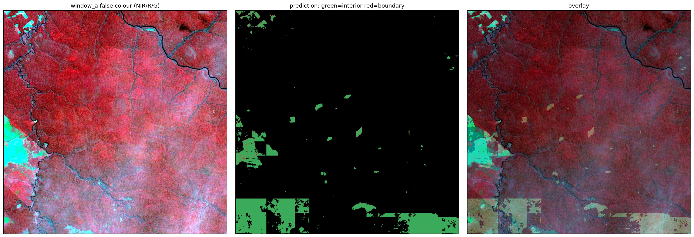


para soy small
Zoom this site →soy, Para (small fields, tile median 6.4 ha, WRS-2 227/062)
| 1986 | 2005 | 2024 | 1986→2024 | |
|---|---|---|---|---|
| objects found | 440 | 2,150 | 1,811 | +312% |
| median ha | 2.18 | 2.36 | 2.31 | — |
| p10 ha | 0.44 | 0.43 | 0.41 | — |
| p90 ha | 44.00 | 30.59 | 36.57 | — |
| total ha | 18,715.50 | 26,202.50 | 33,457.50 | +79% |
1986 · Landsat 5 TM planting 1985-10-01/1986-01-31 · harvest 1986-02-01/1986-05-31
LT05_L2SP_227062_19850811, LT05_L2SP_227062_19850827, LT05_L2SP_227062_19850912, LT05_L2SP_227062_19851014, LT05_L2SP_227062_19851115, LT05_L2SP_227062_19851201, LT05_L2SP_227062_19860729
2005 · Landsat 5 TM planting 2004-10-01/2005-01-31 · harvest 2005-02-01/2005-05-31
LT05_L2SP_227062_20040831, LT05_L2SP_227062_20050530_, LT05_L2SP_227062_20050615, LT05_L2SP_227062_20050701, LT05_L2SP_227062_20050717, LT05_L2SP_227062_20050802, LT05_L2SP_227062_20050818, LT05_L2SP_227062_20050903, LT05_L2SP_227062_20050919
2024 planting 2023-10-01/2024-01-31 · harvest 2024-02-01/2024-05-31
LC08_L2SP_227062_20240315_, LC08_L2SP_227062_20240331, LC08_L2SP_227062_20240502, LC09_L2SP_227062_20231116, LC09_L2SP_227062_20240323, LC09_L2SP_227062_20240408, LC09_L2SP_227062_20240424, LC09_L2SP_227062_20240510, LC09_L2SP_227062_20240526
object count by size 198620052024
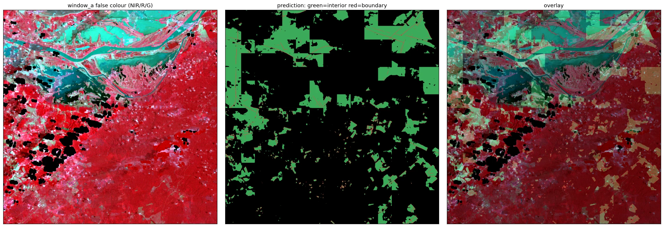


mato grosso soy large
Zoom this site →soy, Mato Grosso (large fields, tile median 118.8 ha, WRS-2 225/068)
| 1986 | 2005 | 2024 | 1986→2024 | |
|---|---|---|---|---|
| objects found | 86 | 166 | 208 | +142% |
| median ha | 14.29 | 87.79 | 148.09 | — |
| p10 ha | 1.28 | 1.42 | 17.44 | — |
| p90 ha | 157.25 | 544.41 | 280.07 | — |
| total ha | 5,439.10 | 29,053.70 | 31,859.40 | +486% |
1986 · Landsat 5 TM planting 1985-07-01/1985-11-30 · harvest 1986-01-01/1986-05-30
LT05_L2SP_225068_19850829, LT05_L2SP_225068_19860528
2005 · Landsat 5 TM planting 2004-07-01/2004-11-30 · harvest 2005-01-01/2005-05-30
LT05_L2SP_225068_20041004, LT05_L2SP_225068_20050516
2024 planting 2023-07-01/2023-11-30 · harvest 2024-01-01/2024-05-30
LC08_L2SP_225068_20240520, LC09_L2SP_225068_20231118
object count by size 198620052024
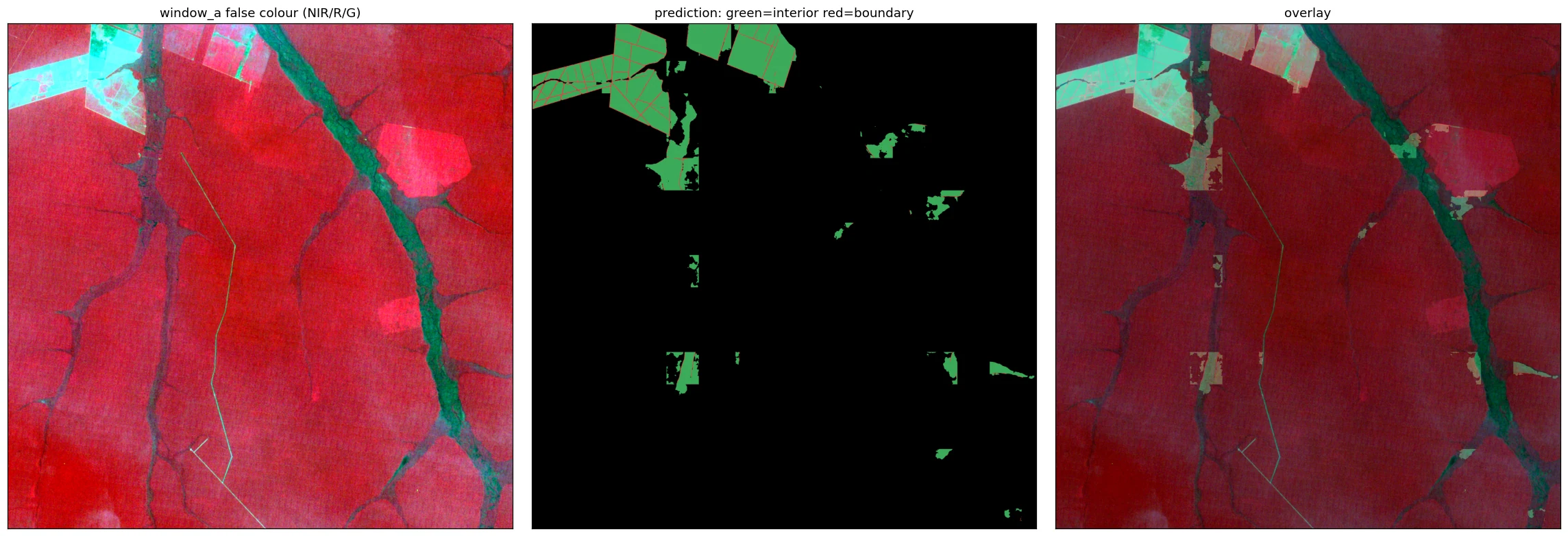


para palm
Zoom this site →palm, Para (uniform fields, tile median 8.0 ha, WRS-2 223/062)
| 1986 | 2005 | 2024 | 1986→2024 | |
|---|---|---|---|---|
| objects found | 469 | 963 | 1,560 | +233% |
| median ha | 1.38 | 11.34 | 9.33 | — |
| p10 ha | 0.36 | 0.76 | 0.71 | — |
| p90 ha | 52.06 | 85.27 | 53.66 | — |
| total ha | 15,717.50 | 31,283.40 | 34,692.30 | +121% |
1986 · Landsat 5 TM planting 1985-10-01/1986-01-31 · harvest 1986-02-01/1986-05-31
LT05_L2SP_223062_19851002, LT05_L2SP_223062_19851018, LT05_L2SP_223062_19851103, LT05_L2SP_223062_19860223, LT05_L2SP_223062_19860311, LT05_L2SP_223062_19860327, LT05_L2SP_223062_19860428, LT05_L2SP_223062_19860514, LT05_L2SP_223062_19860530, LT05_L2SP_224062_19851009, LT05_L2SP_224062_19851025, LT05_L2SP_224062_19851126
2005 · Landsat 5 TM planting 2004-10-01/2005-01-31 · harvest 2005-02-01/2005-05-31
LT05_L2SP_223062_20040904, LT05_L2SP_223062_20050518_, LT05_L2SP_223062_20050603, LT05_L2SP_223062_20050619, LT05_L2SP_223062_20050721, LT05_L2SP_223062_20050806, LT05_L2SP_223062_20050822, LT05_L2SP_223062_20050907, LT05_L2SP_223062_20050923
2024 planting 2023-10-01/2024-01-31 · harvest 2024-02-01/2024-05-31
LC08_L2SP_223062_20240404_, LC08_L2SP_223062_20240420, LC08_L2SP_223062_20240506, LC08_L2SP_223062_20240522, LC09_L2SP_223062_20231019, LC09_L2SP_223062_20240412, LC09_L2SP_223062_20240428, LC09_L2SP_223062_20240514, LC09_L2SP_223062_20240530
object count by size 198620052024
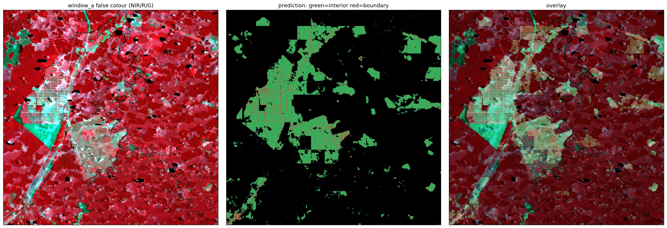


Earlier hand-chosen sites
Polygon floor 1.0 ha, the production filter. 2024 only.
pucallpa palm
Pucallpa, Peru - oil palm plantations
| objects found | 932 |
|---|---|
| median ha | 5.31 |
| p10 ha | 1.30 |
| p90 ha | 56.59 |
| total ha | 24,643.40 |
object count by size2024

matogrosso soy
Sorriso / Lucas do Rio Verde - industrial soy
| objects found | 1,017 |
|---|---|
| median ha | 9.77 |
| p10 ha | 1.54 |
| p90 ha | 159.23 |
| total ha | 49,912.80 |
object count by size2024

acre pasture
Rio Branco / BR-364 - Amazonian pasture
| objects found | 1,299 |
|---|---|
| median ha | 9.55 |
| p10 ha | 1.46 |
| p90 ha | 74.28 |
| total ha | 41,046.20 |
object count by size2024

rondonia pasture
Ariquemes / Ji-Parana - fishbone pasture
| objects found | 2,591 |
|---|---|
| median ha | 8.42 |
| p10 ha | 1.60 |
| p90 ha | 52.17 |
| total ha | 56,378.90 |
object count by size2024

altoparana hills
Serra gaucha - mountainous mixed agriculture
| objects found | 3,471 |
|---|---|
| median ha | 1.86 |
| p10 ha | 1.10 |
| p90 ha | 7.34 |
| total ha | 14,282.30 |
object count by size2024

paraguay colonias
Itapua colonias - smallholder
| objects found | 4,327 |
|---|---|
| median ha | 4.19 |
| p10 ha | 1.30 |
| p90 ha | 22.56 |
| total ha | 41,290.90 |
object count by size2024

irece bahia
Irece microregion - smallholder beans/onion
| objects found | 3,878 |
|---|---|
| median ha | 3.98 |
| p10 ha | 1.29 |
| p90 ha | 23.03 |
| total ha | 45,542.40 |
object count by size2024
